Trekking in Misti Volcano
Sport: Trekking
Route Description
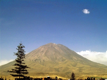
The Misti is considered the most outstanding tourist attraction in Arequipa and is the meeting point for sports adventurers seeking a breathtaking view of the entire White City.
At an altitude of 5,825 meters, between the districts of Miraflores and Chiguata in Arequipa, we find the Misti volcano. This is the most representative symbol of Arequipa, as thanks to the volcano's acidic eruptions, this department has some of the richest lands for agricultural activity. Trekking at high altitude on the Misti does not require overly tedious preparation, as the only difficulty when climbing is the volcanic ash and sand. However, to avoid inconveniences, prior acclimatization is necessary. The round trip trek takes two days and one night to complete.
The Trekking Route
To reach the Misti volcano, there are two access routes.
Route 1
Through Chiguata. From the city of Arequipa, a private transport takes us to the town of Chiguata. This village is located about 30 km from the city and sits at an altitude of around 2,970 meters above sea level. From this point, the journey continues towards the Nido de Águilas base camp to ascend the following day.
In Chiguata, you can admire a spectacular landscape composed of terraces and houses built with stone and mud, with gabled roofs to protect them from rain. Additionally, there is the colonial-era Espíritu Santo church, from whose dome you can see 24 carved figures of saints and cherubs.
Route 2
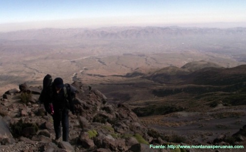
Through Aguada Blanca. From the city of Arequipa, take the road via Cabrerías up to 4,000 meters above sea level until reaching the foothills of the Misti. This journey takes about three hours. During the trek in the Aguada Blanca and Salinas National Reserve, you can observe vicuñas enjoying their freedom, vizcachas, birds like hawks and eagles, Andean foxes, and even wild guanacos in their natural state.
From these bases, the ascent trek begins. The entire uphill climb takes an average of eight hours. The climb is not technically difficult, although the sandy terrain, dry air, and altitude should be taken into account.
Technical Details
|
Location: Southwest Western Cordillera, 150 km from the city of Arequipa |
Difficulty: Easy to Intermediate |
| Altitude: 5,825 meters above sea level | Duration: Two days, one night |
Best Travel Season
Arequipa has a temperate climate, with temperatures ranging from 10°C to 24°C. Winter nights and mornings are cold, but the sky clears up during the day. The rainy season is from January to March, so it is recommended to visit between April and December.
What to Bring
- Leather or synthetic boots with sturdy soles
- Sleeping bag
- Wool jacket
- Trekking pants
- Thick socks (to prevent blisters)
- Wool hat
- Gloves (ski gloves)
- Wide-brimmed hat
- High-quality sunglasses and sunscreen
- Flashlight with batteries
- First aid kit
- At least 4 liters of water
Key Data about Volcán Misti
Altitude
5822.50
Best Season
Abril a Noviembre (temporada seca)
Climate
Árido de alta montaña
Natural Region
Sierra
Distance
20.50 km
🏃 Available Activities
There are no specific activities registered for this route at this time.
Explore All ActivitiesPlanifica tu aventura
Solicita información o cotizaciones para esta experiencia.
Trekking in Misti Volcano