Trekking in Huayhuash Mountain Range
Sport: Trekking
Route Description
"The beautiful hike to the Huayhuash Mountain Range is the most astonishing route in Peru, welcoming adventure tourists and trekking enthusiasts with stunning landscapes and a demanding, yet rewarding excursion within the Andes Mountain Range."
The Huayhuash Mountain Range is located 120 kilometers from the Pacific Ocean. It belongs to the Andes Mountain Range in Peru. It is the second highest mountain range in the world after the Cordillera Blanca. The population is scarce, with the closest villages being Chiquián (3,400m) and Cajatambo (3,375m). Additionally, it has one of the most fragile ecosystems in Peru, but it remains intact, making it very popular among adventure tourists for trekking.
Climate in the Huayhuash Mountain Range:
The climate varies significantly, with semi-tropical and temperate temperatures. The valleys at lower altitudes have a more temperate, almost warm climate. The annual temperature is approximately 20 degrees during the day and between 5 to 15 degrees at night.
October - March: It is not recommended to travel during this season, as it is the rainy season and the excursion can be challenging. The rains usually fall around midday, so it is better to hike during the day.
April - September: It is highly recommended to go trekking during these months as it is the summer season.
Trekking Route in the Huayhuash Mountain Range:
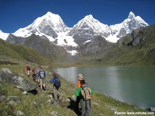
The routes for exploring the Huayhuash Mountain Range last around 10 to 12 days, so it is advisable to be well-prepared for the journey and have acclimatized beforehand.
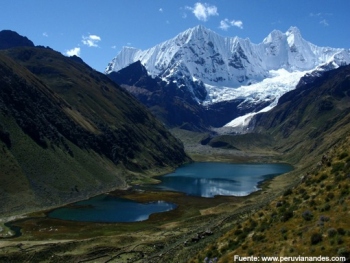
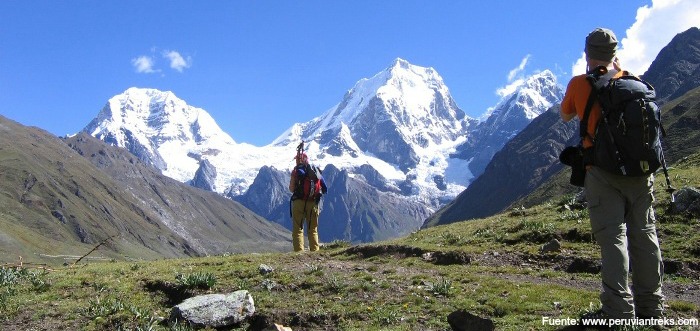
Starting from the city of Huaraz, we must begin the journey reaching Rondoy at 4,170 meters above sea level to find transportation that will take us to Cashan at 4,810 meters above sea level, where we will ascend 640m to Laguna Mitucocha, then reach the Jirishanca Pass at 4,800 meters above sea level and climb 570 meters where we can observe various snow-capped peaks and head to Carhuacocha, where camping is possible. Each step-by-step journey takes approximately five to six hours.
From Carhuacocha, the path becomes more challenging due to the hours of trekking. We must follow the route 520m upwards, where we will see four lakes of different colors, continuing on the route we will walk to Siula Pass at 4,800 meters above sea level, then reach Trapecio Pass at 5,200 meters above sea level and admire the snow-capped peaks the landscape presents.
At Huayllapa at 3,630 meters above sea level, we must climb a 1,170m elevation to reach the famous Diablo Mudo Peak at 5,350 meters above sea level and descend through the Huacrish Gorge to Jahuacocha Lake. The time it takes for this stretch is 9 to 10 hours, to reach the final pass at Pampallamac at 4,300 meters above sea level with a 200m descent. After descending to Llamac at 1,000 meters, transportation can be found to return to the city of Huaraz, thus concluding the trekking adventure.
Tourist Attractions in the Huayhuash Mountain Range:
- Lakes of 4 different colors (Siulacocha Lake, Quesillococha Chico, Quesillococha Grande, Asulcocha).
- Snow-capped peaks Cuyuc, Ninashanca, Rondoy, and Jirishanca.
- Diablo Mudo Peak.
- Jahuacocha Lake.
Technical Data of the Huayhuash Mountain Range
| Location: 120 Km. from the Pacific Ocean | Maximum Altitude: 3,300 - 5,000 meters above sea level |
| Climate: Semitropical - Temperate | Best Season: April - September |
| Difficulty Level: Moderate |
Recommendations for Trekking in the Huayhuash Mountain Range:
- Sleeping bag.
- Waterproof pants and jacket.
- Down jacket.
- Trekking poles.
- Trekking shoes.
- Flashlight and batteries.
- Warm hat.
- Insect repellent.
- Sunscreen.
- Sunglasses with UV protection.
- Water purifier.
- First aid kit.
Key Data about Cordillera Huayhuash
Altitude
4500.00
Best Season
Mayo a Septiembre (temporada seca)
Climate
Frío de alta montaña
Natural Region
Sierra
Distance
80.00 km
🏃 Available Activities
There are no specific activities registered for this route at this time.
Explore All ActivitiesPlanifica tu aventura
Solicita información o cotizaciones para esta experiencia.
Trekking in Huayhuash Mountain Range