Paragliding in Chincha
Sport: Parapente
Route Description
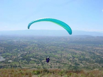
Laderas is located 185 km south of the city of Lima, surrounded by exotic landscapes, wide beaches, green swamps, and wild nature sites. The flight ranges from 60 to 200 meters in height, starting in the Chincha Valley and reaching the Cañete Valley, with a distance of approximately 35 km between them. The round trip flight (70 km) lasts about 4 hours, with the speed record for this distance being 2 hours and 20 minutes.
The flight is dynamic with the presence of very small thermals that are not turned but rather surfed. There are two points of difficulty, but with a bit of precision, wind, and skill, these can be overcome.
Paragliding in Chincha is an interesting sport that is gradually gaining more practitioners. Chincha is located in the Ica region. Flights in Chincha take place in the Chincha Valley, where the slopes reach heights ranging from 60 to 200 meters. Flights starting in this valley usually reach Cañete, and the total journey can be completed in an average of four hours.
Due to the valley's conditions, the flight path is often quite close to the slopes, so extreme care must be taken to avoid any forced landings. Any time is good for paragliding in this area of Chincha; however, it is recommended to obtain prior information about wind conditions.
Key Data about Chincha
Altitude
200.00
Best Season
Abril a Octubre (temporada seca)
Climate
Desértico costero
Natural Region
Costa
Distance
70.00 km
🏃 Available Activities
There are no specific activities registered for this route at this time.
Explore All ActivitiesPlanifica tu aventura
Solicita información o cotizaciones para esta experiencia.
Paragliding in Chincha