Climbing in Nevado Vallunaraju
Sport: Escalada
Route Description
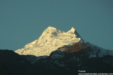
"The Vallunaraju snow-capped mountain is one of the most striking views of the city of Huaraz, located in the heart of the Cordillera Blanca. It is very popular among amateur climbers as it is a mountain for acclimatization and provides an unforgettable experience for adventure sports enthusiasts."
The Vallunaraju Snow-Capped Mountain is located on the northern side of the Ranrapalca snow-capped mountain in the city of Huaraz, forming part of the mountain range of the Cordillera Blanca. This mountain is suitable for amateur athletes, mountain climbers with little experience, or people who wish to take mountaineering courses, rescue courses, etc., as it has an altitude of 5,686 meters above sea level.
Climate in Vallunaraju Snow-Capped Mountain:
Its climate is glacial and dry, although at the foot of the mountain it can be temperate during certain seasons.
June - August: This is a recommended time as there are fewer weather-related issues and the environment is temperate.
Route to Vallunaraju Snow-Capped Mountain:
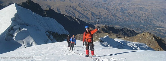
You must depart from Huaraz towards the Vallunaraju Snow-Capped Mountain located in the Llaca Gorge. In this place, you should arrange for transportation to carry the camping equipment. You must return 180 meters from the Huaraz trail, then head right onto a path and walk towards the base of the glacier in the Vallunaraju Moraine field.
Once you reach the Moraine, you should ascend towards the summit on a short 35° to 40° slope, then continue along the glacier on short slopes towards the left side of the South Vallunaraju and reach the Col that connects both summits. Take the left summit with a 40° slope and finally reach the summit.
Technical Data of Vallunaraju Snow-Capped Mountain:
| Location: Cordillera Blanca - Huaraz | Altitude: 5,686 meters above sea level |
| Climate: Glacial - Dry | Season: June - August |
| Difficulty Level: Easy | Type of Climbing: Ice Climbing |
Key Data about Nevado Vallunaraju
Altitude
5686.50
Best Season
Mayo a Septiembre (temporada seca)
Climate
Frío de alta montaña
Natural Region
Sierra
Distance
0.80 km
🏃 Available Activities
There are no specific activities registered for this route at this time.
Explore All ActivitiesPlanifica tu aventura
Solicita información o cotizaciones para esta experiencia.
Climbing in Nevado Vallunaraju