Climbing in Nevado Chopicalqui
Sport: Escalada
Route Description
"The Nevado Chopicalqui is one of the most challenging peaks for climbing in Ancash, but it is highly visited by thrill-seekers from various parts of the world. Undoubtedly an extreme experience."
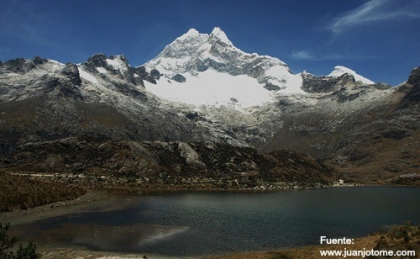
The mountain Chopicalqui is located in the province of Yungay in the department of Ancash. It stands at an altitude of 6,354 meters above sea level and is one of Peru's giant mountains, also known as the third Huascarán or Huascarán este.
There are two different starting points on the glacier, so the climber must choose between one or the other, the difference lies in the altitude, one is at 5,300 meters above sea level and the other at approximately 5,600 meters above sea level. The choice depends on the physical condition of the athlete.
The mountain is located right at the end of the Llanganuco Valley, flanked to the north by the Huandoy peaks and the impressive Chacraraju, and to the south by South Huascarán and North Huascarán. The road that leads into the valley borders the beautiful emerald-colored lakes of Llanganuco.
Weather in Nevado Chopicalqui:
- May – October: The weather is dry and sunny during this period, making it highly recommended to visit at this time.
- December – March: It is the rainy season caused by humid winds.
Route to reach Nevado Chopicalqui:
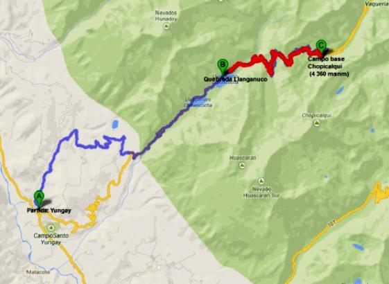
If traveling from Lima, you must head to the city of Huaraz to acclimatize at Laguna de Churup at 4,450 meters above sea level. Following the route, you should head towards the northern part of the Callejón de Huaylas, until you reach the city of Yungay and ascend to Quebrada Llanganuco, passing by the Chinancocha and Orconcocha lakes and Cebollapampa. Continuing the ascent, you must head towards Portachuelo de Llanganuco and finally reach the base camp of Chopicalqui at 4,350 meters above sea level to begin the climb to the summit.
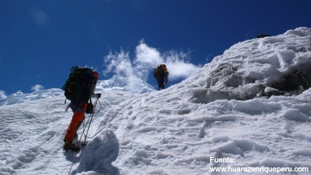
The path to the glacier is quite strenuous and marked by stone cairns. The ascent is dangerous as rocks fall from above the wall, so it is recommended to pass those points quickly, without grouping together and wearing a helmet.
 �
�
Technical Data of Nevado Chopicalqui
| Location: Yungay, Ancash | Recommended Season: May to September |
| Maximum Altitude: 6,354 masl | Type of Climbing: Ice climbing |
| Summit: Icy | Difficulty Level: Difficult |
What to bring for climbing in Nevado Chopicalqui?
- High mountain boots.
- Thermal socks.
- Fleece or wool gloves.
- Sun hat.
- Cold weather hat (fleece or other).
- Microfiber and thermal shirts.
- Fleece jacket.
- Waterproof windbreaker.
- Waterproof pants.
- Waterproof layer.
- Altitude goggles (with side protection).
- Backpack.
- Water bottle.
- Headlamp (with spare bulbs and batteries).
- High-altitude sleeping bag (down).
Key Data about Nevado Chopicalqui
Altitude
6354.50
Best Season
Mayo a Septiembre (temporada seca)
Climate
Frío de alta montaña
Natural Region
Sierra
Distance
0.50 km
🏃 Available Activities
There are no specific activities registered for this route at this time.
Explore All ActivitiesPlanifica tu aventura
Solicita información o cotizaciones para esta experiencia.
Climbing in Nevado Chopicalqui