Mountain Climbing in Chinchey Mountain
Sport: Escalada
Route Description
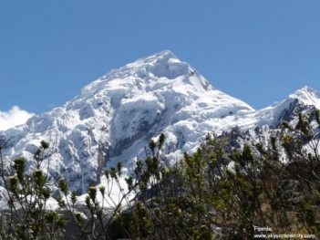
"The Nevado Chinchey is one of the highest peaks in the Cordillera Blanca. It showcases to climbers who reach its summit, beautiful landscapes and neighboring mountains that make this adventure tourism the most impressive."
The Nevado Chinchey is located in the Cordillera Blanca, considered one of the highest peaks in this mountain range. It stands at an altitude of 6,309 meters above sea level. It houses various mountains, which is why it is known as the "Chinchey Massif."
Climate in Nevado Chinchey:
The climate is icy, but very unstable and presents occasional natural accidents.
May - September: This period is recommended due to the dry weather in those months.
Route to reach Nevado Chinchey:
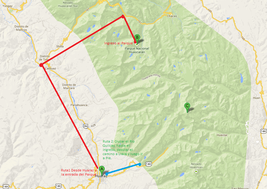
To climb this mountain, you must depart from the city of Huaraz towards Quebrada Quilcayhuanca. You should take transportation from Huaraz to a point called Pitec and pass through the towns of Nueva Florida, Unchus, Llupa, where you must register and pay the entrance fee to Huascarán National Park. Continuing the journey, after 15 minutes you will reach Portada Quilcayhuanca, which is a gate and you must have coordinated with the gatekeeper who has the key, as they are located in Llupa. All arrangements should be made a day in advance.
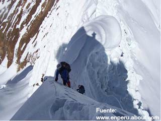
At this point, you will have reached the head of Quebrada Quilcayhuanca, which intersects with Quebrada Cayesh, and about four hours of travel will have passed to observe a valley of rocky cliffs. You will have reached your final destination.
Technical Data for Nevado Chinchey:
| Location: Cordillera Blanca - Ancash | Altitude: 6,309 meters above sea level |
| Climate: Cold - Icy | Best Season: May - September |
| Difficulty Level: Difficult | Climbing Type: Ice - Rock |
What to bring for climbing Nevado Chinchey?
- Headlamp.
- First aid kit.
- Sunscreen.
- Water bottle.
- Down jacket.
- Windbreaker.
- Harness.
- Ice axe.
- Climbing boots.
- Crampons.
- Helmet.
- Ropes, stakes, etc.
Key Data about Montaña Chinchey
Altitude
6300.00
Best Season
Mayo a Septiembre (temporada seca)
Climate
Frío de alta montaña
Natural Region
Sierra
Distance
0.50 km
🏃 Available Activities
There are no specific activities registered for this route at this time.
Explore All ActivitiesPlanifica tu aventura
Solicita información o cotizaciones para esta experiencia.
Mountain Climbing in Chinchey Mountain