Rock Climbing at Laguna Antacocha
Sport: Escalada
Route Description
"Antacocha is a must-visit destination for the new routes it offers in the province of Ancash. It is one of the most exciting routes for rock climbing, being highly frequented by adventure sports enthusiasts from around the world."
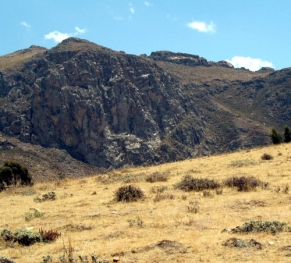
Just 8 km northeast of the main square of Recuay, in Ancash, we find Antacocha, a perfect place for rock climbing. It is located at an altitude of about 3,394 meters above sea level on the Cordillera Negra. Its rock walls have a unique geography that invites adventure, and although annual championships are held in this area, there are many routes waiting to be opened by daring athletes.
Among the attractions we find is the impressive view towards the Cordillera Blanca, where the Shaqusha and Huantsón peaks stand out. Additionally, a beautiful crop field can be seen next to a small lagoon.
Antacocha's Climate:
The climate is temperate-dry throughout the day, with cold nights. It has an average temperature of 19°C, and frost is sometimes present.
April - September: It is a great time to go rock climbing in the area.
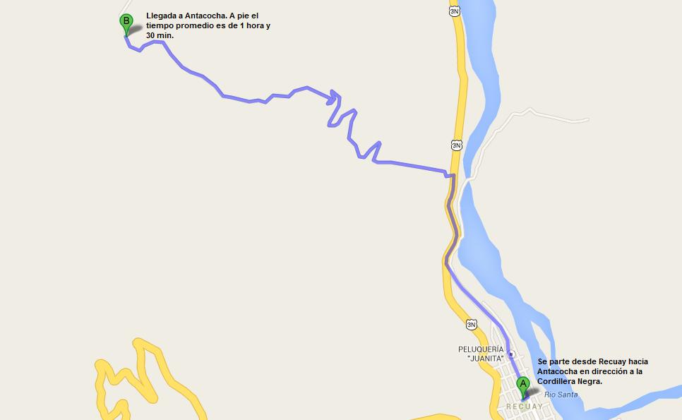
Route to reach Antacocha:
If coming from Lima, take a bus heading to Recuay, Ancash. The estimated travel time for this journey is 5 hours. To reach our destination, Antacocha, we must take a dirt road that goes from the cemetery of Recuay towards the Cordillera Negra and enter the area about 15 minutes further.
Climbing Routes:
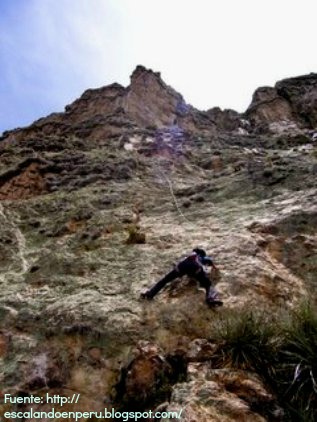
The normal route:
This route has a height of 175 meters and consists of four pitches to climb. It is advisable to use a 60-meter rope, as the second pitch is that long. After finishing the first pitch, there is a 6-meter horizontal traverse to the left.
Dios Hook:
Following the normal route, this route begins. Dios Hook has an approximate 80° inclination, and small edges help test our balance. After this second pitch, walk upwards and descend on the lower part of the mountain, returning to the valley.
Maya Cashca:
This route is about 40 meters long and starts to the right of the Normal Route. Descending, we find bolts and carabiners for rappelling.
Tenosh:
This route starts to the right, ending at Maya Cashca. As one of the most used routes, it is fully equipped and ready for climbing. The descent on this route is also by rappel.
Technical Data of Antacocha:
| Location: Recuay - Ancash | Altitude: 3,394 meters above sea level |
| Climate: Temperate - Dry | Best Season: April - September |
| Difficulty Level: Intermediate | Climbing Type: Rock Climbing |
What to bring for rock climbing in Antacocha?
- Mountain boots.
- Thermal socks.
- Gloves with wool or fleece lining.
- Climbing pants.
- Drinking water.
- Flashlight with spare bulb and battery.
- Sunscreen.
- Tent.
- First aid kit.
Key Data about Laguna Antacocha
Altitude
4200.50
Best Season
Mayo a Septiembre (temporada seca)
Climate
Frío de alta montaña
Natural Region
Sierra
Distance
0.50 km
🏃 Available Activities on Laguna Antacocha
💡 Tip: These activities are specifically designed for this route. Each one offers a unique experience that complements the main route.
Planifica tu aventura
Solicita información o cotizaciones para esta experiencia.
Rock Climbing at Laguna Antacocha