Cycling in Platanales de Totoritas
Sport: Ciclismo
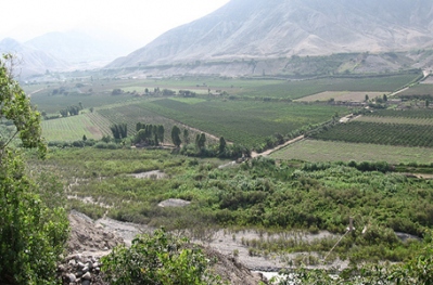
Route Description
"Totoritas is a very warm and beautiful place due to its beaches and sites, but it is also one of the most well-known routes for cycling professionals, who visit the city of Mala every year for the championships held in that area."

Totoritas is located in the resort near the town of Mala in Cañete, 81 km south of Lima. It has an approximate altitude of 650 meters above sea level.
Climate in the Platanales of Totoritas:
The climate in Totoritas is temperate almost all year round, but with strong winds.
December - March: It is the best season for cycling, as thousands of athletes gather in these months to ride the various routes in this area.
Cycling Route in the Platanales of Totoritas:
You should take the route starting from Totoritas, cross under the Panamericana Sur highway bridge, heading towards Mala. On the right, you will see a dirt road that goes through the platanales, where you can easily ride through various circuits.


Technical Data of Totoritas:
| Location: Mala, Cañete | Altitude: 650 meters above sea level |
| Climate: Temperate | Best Season: December - March |
| Difficulty Level: (B) Medium | Modality: Mountain biking |
Key Data about Platanales de Totoritas
Altitude
50.50
Best Season
Noviembre a Abril (temporada seca)
Climate
Cálido y seco
Natural Region
Costa
Distance
35.70 km
🏃 Available Activities
There are no specific activities registered for this route at this time.
Explore All ActivitiesPlanifica tu aventura
Solicita información o cotizaciones para esta experiencia.
Cycling in Platanales de Totoritas