Cycling in Canchacalla
Sport: Ciclismo
Route Description
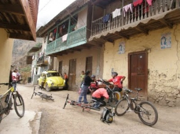
"Canchacalla is one of the areas where various types of adventure sports can be practiced. One of the most visited cycling routes is located in this place, which is why it is recognized among downhill sports enthusiasts as a special area for adventurers."

Canchacalla is located in the province of Huarochirí at an altitude of 2,500 meters above sea level. It is part of the Lima highlands.
Climate in Canchacalla:
The climate in Canchacalla is temperate and warm.
April - November: It is a very good season to explore Canchacalla, due to its temperate climate, which allows for a better appreciation of the area to be explored.
Cycling Route in Canchacalla:
Depart from the center of Lima towards Chosica, to take any bus or transportation that will leave us in Canchacalla. Once in the area, the descent will begin through the Fruit Forest of the Valley, then continue through the towns of Salpán, Lanca, and Cumbe.

Technical Data in Canchacalla:
| Location: Huarochirí - Lima | Altitude: 2,500 meters above sea level |
| Climate: Temperate | Best Season: April - November |
|
Difficulty Level: (B) Medium |
Modality: Downhill |
What to Bring for Downhill in Canchacalla?
- Sunscreen.
- Rehydrating drink.
- Cycling shorts.
- Long-sleeve dry fit cycling jersey.
- Windbreaker jacket.
- Sunglasses.
- Cycling gloves.
Key Data about Canchacalla
Altitude
3200.50
Best Season
Noviembre a Abril (lluvias)
Climate
Templado de montaña
Natural Region
Sierra
Distance
25.50 km
🏃 Available Activities
There are no specific activities registered for this route at this time.
Explore All ActivitiesPlanifica tu aventura
Solicita información o cotizaciones para esta experiencia.
Cycling in Canchacalla