Mountain Biking in Cajamarquilla
Sport: Ciclismo
Route Description
"Cycling in Cajamarquilla is a great alternative for wheel sports enthusiasts. Embarking on this route will be a fascinating journey for all adventure tourists who take on the challenge."

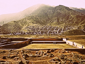
Cajamarquilla is located in the Jicamarca Valley, 24 km from Lima. It sits at an altitude of 340 meters above sea level and covers an area of approximately 167 hectares. It is situated along the Huaycoloro Gorge, between the districts of San Juan de Lurigancho and Chosica.
Climate in Cajamarquilla:
The climate in Cajamarquilla is mostly sunny throughout the year, making it a recommended destination to visit at any time.
December - March: It is not advisable to go cycling during these months due to seasonal rains caused by its proximity to the mountains.
Route to reach and cycle in Cajamarquilla:
To reach Cajamarquilla, take a bus to the central highway until the entrance of Huachipa. From there, enter Cajamarquilla Avenue until reaching a turnoff indicating the way to Santa Cruz neighborhood. About 200 meters from Cajamarquilla, you will find the interpretation center, where you can request access to the "labyrinth" area by paying 5 soles for entry, which is a restored zone.

Technical details of Cajamarquilla:
| Location: Jicamarca Valley, Lima | Altitude: 340 meters above sea level |
| Climate: Warm | Best season: April - November |
| Difficulty level: Easy | Mode: Freestyle |
Key Data about Cajamarquilla
Altitude
400.00
Best Season
Abril a Noviembre (temporada seca)
Climate
Desértico costero
Natural Region
Costa
Distance
25.50 km
🏃 Available Activities
There are no specific activities registered for this route at this time.
Explore All ActivitiesPlanifica tu aventura
Solicita información o cotizaciones para esta experiencia.
Mountain Biking in Cajamarquilla