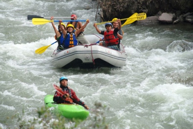
Rafting on the Lurín River
Sport: Canotaje
Route Description
The Lurín River has a length of 108 km, and originates from the melting of the snowcaps of the western mountain range. At its beginning, it is called the Chalilla River, and upon joining the Taquía ravine, it changes its name to the Lurín River.
Location: Lima Department, Cieneguilla District.
Route: It crosses through the districts of Lurín, Pachacamac, Cieneguilla, Antioquia, among others in the Huarochirí province.
Access: You can access the Lurín River 2 blocks from the Cieneguilla roundabout, on Inca Moya Street. You can enter by taxi, moto-taxi, or on foot. Entrance is free.
Temperature: It ranges between 17 and 24°C.
Season: The best time to visit this resource is between January and April when the river flow is high.
Sports: In the area that runs through Cieneguilla, you will find steep ravines enclosed between chains of hills that narrow down. In the Puente Panquilma - Puente Inca Moya section, the river is ideal for rafting and tubing, the latter being an acoustic sport practiced by the locals involving navigating the river's flow on a large tire tube.
Flora and Fauna: In the upper part of the river, you can find shrimps, tilapias, catfish, trouts, river silversides, and guppies (3cm fish). Additionally, it features wild flora including poceas, grasses, wild cane, reeds, and grasses.
Key Data about Lurín
Altitude
500.00
Best Season
Abril a Noviembre (temporada seca)
Climate
Desértico de costa
Natural Region
Costa
Distance
40.00 km
🏃 Available Activities
There are no specific activities registered for this route at this time.
Explore All ActivitiesPlanifica tu aventura
Solicita información o cotizaciones para esta experiencia.
Rafting on the Lurín River