Rafting in Colca
Sport: Canotaje
Route Description
Dare to explore the Colca Canyon, a perfect place for adventure tourism. An adventure at the highest level for extreme adventure enthusiasts, as they will be pleased to discover the Colca Canyon, owner of extraordinary beauty, ideal for practicing canoeing in canoes, rafts, and kayaks.

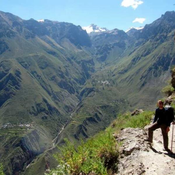
The fury of the waters of the Colca River, which forms the deepest canyon in the world, in the Colca Valley has turned canoeing into one of the most important tourist activities in Peru.
During the last expedition to the Colca Canyon in 2005, it was revealed that in the area adjacent to the town of Quillo Orco, in the district of Huambo, the depth of the Colca Canyon reached 4,160 meters on the north side and 3,600 meters on the south side, making it the second deepest canyon in the world after the Yarlung Tsangpo Canyon in China, which measures 5,590 meters. The Colca Canyon, synonymous with canoeing and rafting, makes it a worldwide classic for canoeing.
Origin of the Colca River
The Colca River originates in the heights of the Yaretane and Torre hills, located at 4,750 meters above sea level, flowing into the Pacific Ocean. The Colca River has a length of over 129 km, with a Southwest-Northeast direction. On the left side, it passes through a chain of mountains of volcanic origin, such as Ampato, Sabancaya, and Hualca Hualca, while on the right side, the volcanic range of Chila is aligned, including Mismi (5,598 meters above sea level). This river flows through the Colca Canyon, contributing to its formation.
- Temperature: The Colca River has a temperature between 5 and 6 degrees Celsius.
- Distance: The river runs through the Colca Canyon, the deepest in the world: 3500m and 100 km long.
- Length: from Colca Majes-Camana: 388 km
Where is the Colca Canyon located?
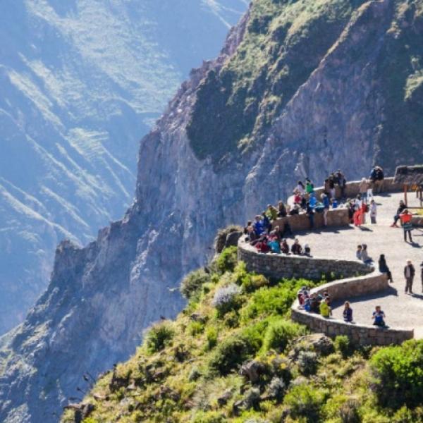
The Colca Canyon is one of the deepest canyons in the world, located in the Colca Valley, Caylloma province at over 3,500 meters above sea level, passing through the Aguada Blanca and Salinas National Reserve north of Arequipa (The White City), between Cabanaconde and Tapay. The Colca Canyon is 165 km from Arequipa to Chivay at 3091 m, and 42 km west of the town of Chivay, the capital of Caylloma, between the mountains of Yajirhua (5,212m) and Lucerna (4,245m).
As the Colca River passes through the ancient town of Maca, and deepens away from the valley floor, this is where the Colca Canyon begins, reaching its greatest depth near the famous Cruz del Condor viewpoint. During its course through the canyon, you will find thermal waters, beautiful geological formations on its banks. Its waters allow for various tourist activities such as kayaking and canoeing.
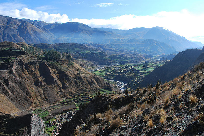 Photo: inkastravelservice.com
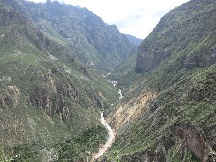 Photo: yusevian.com
Season
- Navigable between May and October. Rafting is recommended from March to December.
- December to March only recommended for specialists and expeditions (upper and middle part).
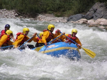
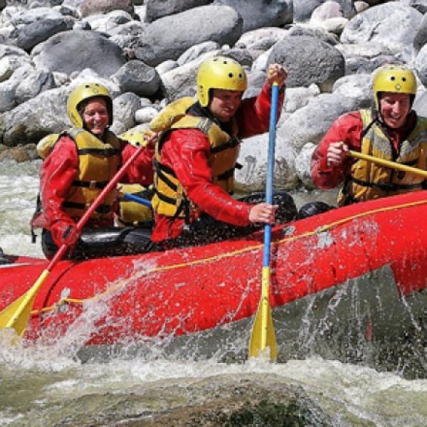
Sections for canoeing, kayaking, and rafting
In the Colca Valley is where the traditional tourist circuits begin, near the town of Chivay, at the foot of Nevado Mismi, the origin of the Amazon River.
First Point: Head to the Colca Valley near the town of Sibayo at a place called IPO.
- IPO - Tuti: Canoeing starts in Ipo, where you can navigate the Colca River for over 7 km, taking approximately an hour and a half to reach the town of Tuti. With Class II and III rapids.
Second Point: The start of the Colca River route begins in Pampa Blanca Callalli, flowing through the high and low areas of the Caylloma province to Majes, presenting long stretches of narrow bottoms carved generally on volcanic rock. Its waters are clear, peaceful, and during the rainy season (January, February, March), its flow increases. Six days of rafting that will end in Class IV and V rapids, stopping at Class VI rapids.
- Huambo: Head from the city of Arequipa to the town of Huambo, where canoeing starts until reaching the Andamayo sector in Castilla, covering a total of 58 kilometers. During the journey, you can appreciate walls carved over time by the waters of the Colca. The rapids here are characterized by being very technical, with Class IV and V rapids. The most challenging rapids come after two days of navigation, by then you should be prepared to have full control of your boats and kayaks.
- Colca River: Start rafting in the world's deepest canyon. With Class III and IV, V rapids for 3 hours, after the journey, you will reach the confluence of the Mamacocha River. From here, the volume of the Colca River almost doubles. In this expedition, you will also encounter Class V rapids. During the journey, you will pass by two landmarks (Laceria Hill and Yajirhua Hill), indicating the deepest part of the Colca Canyon. You can camp on the river's beaches. Along the Colca River route, you can observe monoliths or stone forests standing out from the rest of the landscape, rock walls, and columns throughout the Colca Canyon influenced by the volcanic activities of Sabancaya and Hualca Hualca.
- Arequipa: Once the journey is completed, you can return to the city of Arequipa, approximately a 3-hour drive away.
video: expedicionesyaventuras.com
video: Tom Leeman
Rapids: difficulty level Class II to VI
Colca River excursion time: between 4 to 5 days
Did you know?
- The Colca River flows through all the towns of the Colca Valley: Sibayo, Callalli, Tuti, Canocota, Chivay, Coporaque, Ichupampa, Yanque, Achoma, Maca, Lari, Madrigal, Pinchollo, Cabanaconde.
- As it merges with the Andamayo River, it becomes the Majes River; and when it merges with the Pucayura River near the coast, it becomes the Camaná River.
- Chivay is the largest town in the Colca Valley.
Recommendations:
- It is advisable to be in optimal physical and mental condition.
- Previous experience with Class V rapids.
- You can travel the lower part of the river in rubber rafts. However, only experienced and highly skilled individuals in kayaking can navigate the canyon section.
Key Data about Colca
Altitude
3400.50
Best Season
Abril a Noviembre (temporada seca)
Climate
Templado seco de montaña
Natural Region
Sierra
Distance
25.70 km
🏃 Available Activities on Colca
💡 Tip: These activities are specifically designed for this route. Each one offers a unique experience that complements the main route.
Planifica tu aventura
Solicita información o cotizaciones para esta experiencia.
Rafting in Colca