Trekking ZARATE FORESTS Normal Route 25th Jan
📍 San Bartolomé, huarochirí, Lima
Shared by Jose La Rosa Yabar La Rosa Yabar
Trekking ZARATE FORESTS Normal Route 25th Jan
Jose La Rosa Yabar La Rosa Yabar
27/01/2015
Description
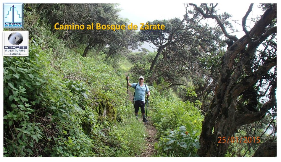
Trekking - ZARATE FORESTS - Normal route - Do25Jan2015
This new Adventure No. 88, was carried out in the Zárate Forest in the district of San Bartolomé, with Raúl Lucho, Rocio, Franc, Roberto, Yoselyn, Vanessa, Robert, Alexis, and Kelly
San Bartolomé is at 1,600 meters above sea level
Pampa Zárate at 3,107 meters above sea level
Elevation gain: +- 1,507m approx.
One-way distance = approx. 16.5 km (round trip)
Total time spent = approx. 10.5 hours in total
This is the first outing where a fee is charged for the guiding. The collected amount will be used to purchase equipment for outings with trekkers.
I arrived at 06:55 at Echenique Park in Chosica, as always had breakfast with Mr. Felix. The trekkers who would participate today were already waiting.
At 08:10, we arrived at the entrance of the Zárate Forest, sorted out the last details, and took the mandatory photos.
I felt unwell as never before, with the urge to return the breakfast and with general discomfort, however, I had to guide them to the Forest, so we started walking. There were experienced trekkers in the group, and they went ahead with Roberto leading. We divided into three groups where Raúl supported us with his great experience.
At 08:20, we started walking along the paved road, making some initial shortcuts to save extra walking.
At 08:43, we found the detour that would take us to the Interpretation Center, crossing farmlands, this steep ascent shortened the time to reach this place.
At 09:20, we reached the Interpretation Center. We rested, hydrated, took photos, and after a few minutes, we continued the ascent through more shortcuts until reaching the road and walking a bit.
At 09:50, we reached the beginning of the traditional trail that would lead us to the forest. The path is well marked and impossible to get lost, except when you reach the Gatera and if you are not attentive, you will continue straight to anywhere but where you should be heading.
We were accompanied by strong sun all the way until a certain hour, as we climbed, the weather became colder.
The ascent is steep and long, however, with perseverance, you manage to reach the top. As you can see in the photos, the slopes are visible at all times, as we had to climb an elevation gain of approximately 1,507m.
At 10:24, As you climb, you realize how the vegetation changes, the higher you go, the more vegetation you see, and you realize that you are entering the domain of the Forest.
In the distance, we saw the clouds in the sky, how impressive their formation with whimsical shapes, and you would like to feel part of them and move like them, they only do it.
At 10:48, we took a short break to hydrate and regain strength.
At 11:15, we took some group photos, as the vegetation invited us to immortalize this moment.
At 11:17, we reached the halfway point, after walking almost 3 hours. It was not yet time for a break, so we kept walking.
At 12:20, the weather cooled down, as the clouds descended, indicating the possibility of rain, however, it gave us relief to continue climbing.
At noon, I was already feeling stomach pain, however, the adrenaline to finish the trek and lead them to the forest gave me the strength to continue, fortunately, the weather helped.
At a certain point, I saw the three friends from the Agrarian University pulling ahead, so I told them to wait for us at the Gatera, as from there onwards they could get lost.
At 12:30, a new break and onwards we went.
At 13:00, we were already in the midst of the forest, greenery all around, where you feel like sitting down and just enjoying nature.
From the high point where we were, we could see the town of Chaute, which I had already visited.
At 14:05, we took some impressive photos, amidst lush trees and abundant vegetation. Truly, when I see the photos, I wish to be in that same place again, well, it will be for another opportunity, maybe in April.
At 14:10, we reached the Gatera, took some photos, and immediately went to catch up with the group of friends from the Agrarian University who had advanced, as they were going to get lost for not knowing the way. I had to walk as fast as I could to catch up with them, and then lead them to the Pampa. I really didn't want to keep walking, I couldn't wait to be home, the discomfort was getting worse, however, onwards we went, there was no other option.
At 14:30, I found them and we continued on the path towards the pampa, looking for the left turn we should take. Finally, we found the detour, and as they told me, they wouldn't have noticed it and would have continued straight, fortunately, I found them. What we did was put vegetation on the wrong path and mark the ground so that the group we thought would come after us could follow it.
With the right path, the guys went ahead until they reached the Pampa, I arrived a few minutes later to take the photos.
At 15:30, we took photos at the Pampa sign, we saw that the fog was descending, and immediately we descended so that we wouldn't be caught by the rain on the way down. We wanted to return through the ridges of the hills by climbing a few more meters, however, the weather was not going to allow it, and the fog could block our path as it did a few weeks ago.
As we descended, the weather cooled down, and as feared, it started to rain, however, the rain was only heavy in a stretch, then it left us, only to return again but with less intensity.
The tiredness was starting to be felt, however, we continued descending as fast as possible so that night wouldn't catch us. There were slippery sections due to the rain, however, with caution, there were no issues.
At 18:30, it was a relief to see the Interpretation Center, we were close, onwards we went.
At 19:00, we were taking the car to Chosica that passed just as we were heading to the San Bartolomé stop.
The group that stayed at the Gatera returned with Raúl.
The first group that reached the pampa with Roberto took the path of the ridges of the hills to return, they had more physical strength.
In the end, everyone was satisfied with this challenging trek.
Thanks to the participants of this trek. We will be scheduling other outings of this level soon.
Thanks to Roberto and Raúl for their support on this trek.
Thanks to all my friends, followers, and occasional readers of these adventures who keep asking for a description of the route and the most descriptive photos. I hope it helps you decide to visit these beautiful places that are very close to Lima at any time.
I will add my number as requested so I can answer any questions you may have. Rpc: 992 891 367.
Email: aventurastours@cedresperu.org
A BIG HUG TO EVERYONE
Location on Map
📍 San Bartolomé, huarochirí, Lima